Mapa de Reconstrucción Escolar
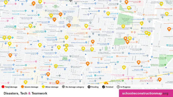 Image credit: IMCO
Project Description
The School Reconstruction Map is an interactive map that shows schools damaged by a series of earthquakes in Mexico in 2017. The map represents the level of damage of each building and its rebuilding status at a glance. Pop-up cards for each school provide more details, including the budget it received and how much it spent.
The lack of data on affected schools was the biggest hurdle this project set out to solve. To collect this data, we built partnerships with public agencies and private enterprises, enabling us to integrate data from all organizations involved in school reconstruction. This included geospatial, administrative, and ad hoc information. By gathering all data in a single, accessible platform, we sought to increase cooperation between public and private stakeholders, enhance accountability, and facilitate transparency in the rebuilding of educational infrastructure.
What was my involvement in this project?
I was responsible for collecting, preparing, and integrating data from a wide range of sources. Periodically, I met with the federal agency responsible for education infrastructure to identify and correct discrepancies across our data inputs. I then liaised with our IT and communications teams to upload and disseminate the results. The Map’s database harmonized inputs from 3 federal government organizations, 12 state education agencies, and 14 private organizations. This work had far-reaching impacts. It was cited in the federal government’s diagnosis of a National Reconstruction Program in 2018 and showcased at the 2019 Paris Peace Forum, where I represented the project.

Additional content for this project can be found below and in the links beneath this page’s main title.